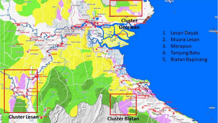
In 2021, the Berau Regency Plantation Service with the support of GIZ through the Low Emission Palm Oil Development (LEOPALD) technical project in collaboration with Operasi Wallacea Terpadu Foundation (OWT) has conducted a Study on the Identification Management Plans Development of High Conservation Value and High Carbon Stock in Plantation Allocation Areas in Berau Regency.
The villages targeted for the study met several criteria, namely: (i) The village is included in the indicative HCV map, (ii) The indicative HCV area represents the ecosystem type, (iii) The indicative HCV area represents the upstream/middle and downstream ecosystem conditions, (iv) The village has a large indicative HCV area (>2000 ha), (v) The indicative HCV area has good forest cover, (vi) The indicative HCV area is adjacent to a forest area that has biodiversity, (vii) The village has or is in the process of preparing a village Land Use Plan (RTGL) map, (viii) The village/community plans to manage the HCV area.
The target villages are divided into three clusters (landscapes), namely:
- Lesan Cluster/Landscape, consisting of 3 villages,: Muara Lesan Village, Lesan Dayak, and Merapun. These villages are located in Kelay District, representing the upstream and middle ecosystems, dry land forest ecosystem type dominated by clay.
- Tanjung Batu Cluster/Landscape, consisting of 1 village, namely: Tanjung Batu Village located in Derawan District, representing the middle and downstream ecosystems, and dry land forest ecosystem type dominated by sand and mangrove forest ecosystem.
- Biatan Cluster/Landscape, consisting of 1 village, namely; Biatan Bapinang Village located in Biatan District, representing the middle and downstream ecosystems.
The study results show that the indicative HCV areas in the target study villages generally meet the high conservation values of HCV 1, HCV 2, HCV 3, HCV 4, and HCV 5.
